The ghost town and the train house

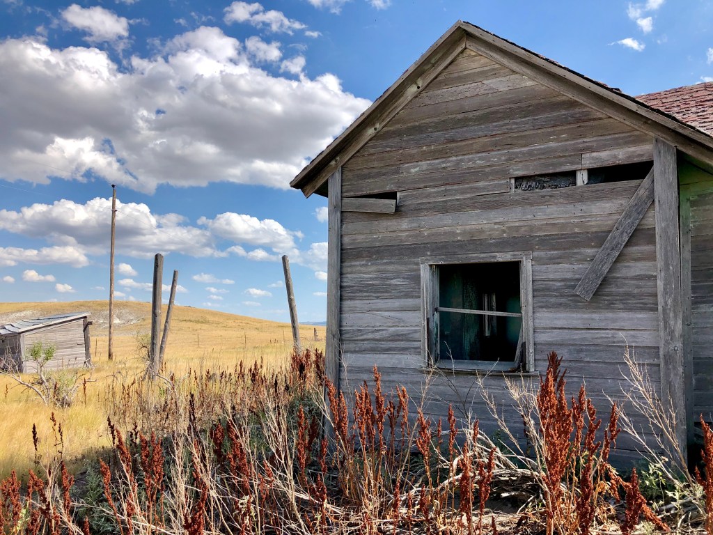
The first thing I noticed was the vast emptiness. I looked around and realized just how alone I was. Rolling hills of grass reached out as far as the eye could see to touch the sky. And it was so quiet. There was no sound except for the wind; hot and dry and incessant. It all gave me an odd feeling of claustrophobia to be in a space with so much nothingness. Grass and sky and nothing more, save for the deserted house next to me. How had someone ever lived here?

We had headed south out of South Dakota, driving in a land so foreign looking to us easterners. A dry landscape of brown and muted greens had replaced the bright greens and humidity of the east coast.

Soon we passed through Ardmore, a modern day ghost town on the South Dakota-Nebraska border. Abandoned homes and cars still stand; its residents finally abandoning the town in the 1980’s due to lack of fresh drinking water. Ardmore was a town founded by the railroads and became a thriving community as its people managed to make a living on the desolate plains. But when the trains that had once brought clean drinking water to the town no longer stopped, the town could not survive. It literally dried up and it’s residents abandoned the town leaving what remained to slowly be reclaimed by the grasslands.

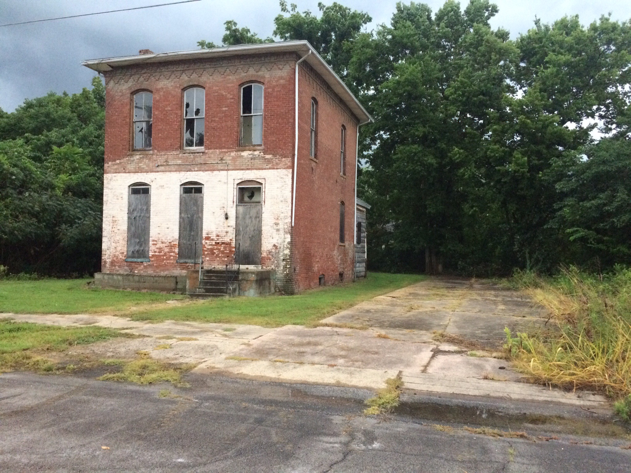
Once in Nebraska we turned off of the tarmac and onto a crushed gravel road. We drove past a couple farms and soon were alone, nothing but miles of grasslands around us as we drove deeper into the landscape, our car kicking up a plume of dry dust so that we could no longer see where we had come from. Our road followed a railroad track which was still in use. We passed no other cars and saw no one as we drove on. After miles of driving through the rolling plains we saw something ahead on our right. An abandoned farmstead. We decided to get out and explore.

The house was set just a little ways off of the gravel road, surrounded by the grassland on all sides. This grass that had looked so soft blowing in the wind from the car window was anything but. The grass was dry and sharp and crushed beneath my feet as I walked along toward the house under the hot sun. I also realized that there were cactus’ mixed in as my heel brushed against one giving me a good scrape. Such a harsh landscape to build a house.

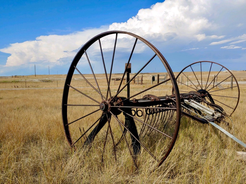
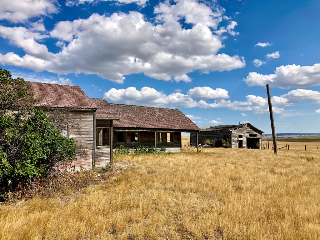
The house was a bit rambling with three separate buildings butting up to each other at 90 degree angles. We speculated that maybe the owners added on to the house as needed. A few outbuildings and farm equipment lay scattered about the property as well. The hot dry wind blew as we explored, rattling a piece of lose roofing.

We walked inside one of the sections of the house and the first thing I noticed was a lack of the mildew smell that’s so prevalent in the abandoned buildings at home where anything left on its own long enough will rot and decay back into the land. Here buildings seemed to reach a sort of dusty mummification, standing proudly as if to prove that someone had once survived in this harsh climate. The second thing I noticed was that this had not started out as a house.

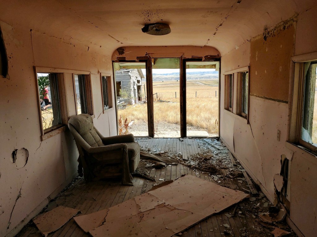
The long, narrow room had walls that rounded up into the ceiling, a seemingly odd choice for such a rustic structure. We looked up and saw an area where the ceiling had come down. Instead of finding roof rafters above the ceiling dry wall, there was the ceiling of a beautiful old train car. It hit us then, the house was made out of old train cars!

There were three train cars to be exact. The owner had moved train cars from the nearby tracks and created a house, drywalling over the inside cars and covering the outside with wood siding and a traditional roof. The cars were placed together to create a home. All throughout the house in places where the dry wall had fallen down you could see the train cars still in really good condition. Such ingenuity!

We wandered around to some of the outbuildings and saw that these too were old train cars. It was easy to spot once we realized what they were. As we explored, we speculated on why the home was built this way. Was it because this was the best option financially for the owner? Or were the railroad cars a temporary solution to a house that just became permanent? Maybe it was just a fulfillment of the dream every child who has read The Boxcar Children has had; to live in a train car? We could only guess. Whatever the reason, it had been someone’s home. A life or lives were lived here, hard work was done, dreams were fulfilled or crushed. And then, in the not so distant past, the home was abandoned and left to the elements.

As we began to leave, I stood alone taking one more look around. The loneliness of this home and this place filled me. Such quiet and isolation. It must have been so difficult to scratch out a life here. Nature appeared to have won, yet I was glad the house remained, standing proud amongst the grasses and the never ending wind. A train whistle blew in the distance and I turned toward our car, ready to be back with my family and keep moving forward down the road.

Getting away from it all during Quarantine

The late afternoon sunlight danced around us; an ever-changing movement of light and dark, warm and cold, as it filtered through the tunnel of trees we walked through at the edge of the lake. The water sparkled as a duck quietly drifted by. I took a deep breath and briefly thought how nice it was to be out hiking away from it all. Then I stopped and laughed because I was hardly “away from it all”.

Our world’s have all become very small this past month. Most of us are in our home now almost 24/7. The place you know better than any place in the world just feels different when you can’t leave it. For some it might be filled with loneliness as you spend each day alone in your home’s rooms and for others your residence might be becoming exceedingly crowded, filled to the brim with family members who are always around, day after day. I, every once in awhile, will feel claustrophobic, missing driving hundreds of miles each day for work.

What helps is getting outside. It’s spring which means the weather here is all over the place. Some days and warm and sunny, others cold and damp. The wind always blows, carrying with it pollen and, some days, the threat of tornadoes. Yet, we get outside daily. With most parks and trails closed and travel discouraged, outside is now what is directly around us. We walk, circling our neighborhood and those nearby. Houses with manicured yards, rows of townhomes with the end units still being framed, apartments with kids on scooters circling the parking lot; we walk past it all. Over and over…and over and over again.

Then one day my son and I decided to venue out of our daily circling on pavement to an area across from one of the developments we frequented. We stepped off of the sidewalk and onto a faint trail and followed it into the “wild” and into our own small adventure.

The trail started around a lake. We passed a number of people who were fishing. I asked a man who was watching his young son cast a line into the lake if they’d caught anything. “Oh yes, we’ve caught a lot,” he told me as he held his hands up to show the size of what they were catching. We continued on and soon reached an ancient man-made dam. Water flowed out of the lake here and disappeared underground as it descended to a river far below. We too turned and scrambled down to the river.

At the river we stood and watched the water that had disappeared underground at the lake’s edge, reappear creating a couple small waterfalls as it flowed into the river. It had rained a lot earlier in the week so the river was high and flowed past us splashing noisily over rocks and creating some nice rapids.

We hiked back up towards the lake, crossing over the dam, and continued on into a large field. As we walked we heard some chattering and saw a bird running along the ground beside us. She ran up to us and then flew in a large circle around us only to land and run beside us again, chattering the entire time. We quickly realized why as we passed a nest with four speckled eggs in it just a foot off the path we were walking along. “Don’t worry, your babies are safe,” we told her as we quickly moved along.

A little further along we came to a basketball hoop in the middle of the field. An old soccer ball lay next to it so we shot a few baskets. It’s all that remains of what was once someone’s home and was a good reminder that we were not on a trail in the wilderness somewhere, but rather we were walking along a bit of land at the edge of civilization. A bit of wild surrounded on every side by suburbia.

In fact, a major highway ran north to south next to us; its noise a constant reminder that we were not in the middle of nowhere.

I love that there are scraps of wild left in the middle of civilization. Places where the road ends and cities have not yet encroached upon. These little pockets of wilderness that are easy to get to and explore. They’re often places where people once were and have left, allowing nature to once again take over. And nature does take over; the trees and grasses and birds and deer not caring that they are near civilization as they create their own pocket of wild.

As we continued on we came upon more old homesites. Nothing was left but the flat area where a home once stood and a few trees that would have shaded the house from summer’s heat. Here, the homes would have overlooked the lake. We stood in the empty space and, with the birds chirping around us and a warm breeze lifting our hair, for a moment we could imagine how peaceful it would have been to have a home here. The only sound’s then being the wind in the trees and water lapping along the shore. The spell was broken as a semi drove by on the highway behind us and we moved on, exploring our bit of wilderness.

How to add more adventure to life

It had been a lonely month. A month of solitude and forced rest. And now, driving through the barren winter fields, vast and silent and so still, I felt it all catching up with me. The boredom, the slight depression, the sudden slamming to a halt of any and all movement; I was so over it.

Continue reading “How to add more adventure to life”

The underwater ghost town

Tennessee is a beautiful state with amazing state parks. Parks that range from high mountain peaks to the Mississippi delta, from battle fields to Native American burial grounds, from gorgeous blue lakes to diverse river systems. There’s just so much beauty and variety. So, I’ve made it a goal of mine to visit every state park in Tennessee in 2018. Below is my story of my adventure at one park.

I stood high on a hill overlooking a vast expanse of water far below me. The lake, glistening blue in the late afternoon sun, was empty save one man fishing from a boat in a shallow cove. All was quiet and tranquil; a picture-perfect spring day at the lake. But this would have been a much different view some 80 years ago, before everything changed.

Continue reading “The underwater ghost town”

The secret of Old Stone Fort State Park

Early American hunters and traders traveling ancient, well-trodden paths in what is now Middle Tennessee, came upon a stone structure built on a peninsula created by the confluence of two rivers. Rock and earthen 4-6 foot high walls boarded the entire peninsula. This “old stone fort”, as they believed it to be, sat high on bluffs carved out by fast moving rivers and was protected by a moat on one side. They wondered who had built the impressive structure; thinking perhaps it was Buccaneers or Vikings or some other group of early Europeans, but no one knew for sure. The answer, when it was learned, shocked everyone.

January 1st, 2018. Everything always seems so new and fresh and hopeful on January first, as though anything’s possible. I like to start the year with an adventure, hoping it will set the tone for the rest of the year. So, each year, our family does a First Day Hike. State Parks across the country offer these ranger-led hikes as a way to get out, explore, and start the new year right. This year we chose Old Stone Fort State Park.

The day was bitterly cold; wind-chills hovering in the single digits. Usually our entire family goes, but this year because of some sick kids and husband, only my 16 year old son and I ventured out. I bundled up- long underwear, multiple layers of clothes, wool socks, hat, two pair of gloves, face mask, boots, and hand warmers- so that when I was finished, only my nose was showing. My son threw on a fleece, hat, and gloves because he “doesn’t get cold”, and we were off.

I had often passed the brown signs on the highway for Old Stone Fort State Park, but this was our first time at the park. We arrived and went into the museum where I was surprised to see so many people waiting to go on the hike on such a cold day. We all signed in, finished putting on hats and gloves and scarfs and boots, met the ranger, and were off, back into the cold. There ended up being 41 people and 1 dog on the hike which made me happy to see that so many others liked the tradition as much as we did, cold and all!

The hike was a 3 mile loop that followed the rivers. The peninsula that the park is created around is formed by the confluence of the Duck River and Little Duck River. This river system spills over a shelf in the Cumberland Plateau known as the Highland Rim and rapidly drops in elevation as they approach their convergence. This has led to deep gorges cut in the limestone around the peninsula. There are a series many rapids and waterfalls, one of which was our first stop. This was the site of one of a few mills and factories that were built along the river in the 1800s, harnessing the Duck River’s power. We all took picture as the biting wind blew off the water, and then quickly moved along.

The hike continued, heading down now out of the wind, to the fork of the Duck and Little Duck River. We turned to now follow the Little Duck River whose banks were edged with ice as were rocks protruding from the middle of the river. Yet it was a beautiful location. High bluffs behind the river gave privacy to the boulder and tree lined river. It was the perfect spot to wile away a warm summer day- hammock strung between two trees, fishing, napping, and enjoying the peaceful sounds of the river and forest. But not on January 1st! My son and I vowed to come back in the summer!

The Little Duck turns sharply here, forming a horseshoe. We followed it until we came to the base of a narrow ridge. The trail turned and we began to climb away from the river up the spine of the ridge. We could now see why the trail we were on is named Backbone Trail. We hiked along the narrow ridge, the river far below us on both sides. Then it was back down the spine.

Back in the bottom of the forest again, we reached the Moat Trail; a narrow flat open section. This was where early settlers thought the ancient moat that protected the fort was located. But it never was a moat at all! Our ranger told us that they actually think the Little Duck River once flowed here before, at some point, it rerouted to where it is now. We followed the moat/riverbed for awhile and then the trail turned and climbed sharply. This is the steepest section of the trail, heading up and out back to the Old Stone Fort high on the peninsula. The trail continued with the open grassy area that was the supposed fort on our left and the river flowing through rapids and more waterfalls far below us on the right.

And then we learned the truth! This was not an old stone fort as was once thought, but rather an ancient ceremonial site dating back to 30-430AD. Native Americans, not Europeans, had built this gradually over several hundred years. This was before the tribes of Native Americans that we know today even existed. It is thought that no one ever lived here, but would journey to the location for ceremonies. They have found that the sun rises perfectly down the center of the path into the site during the Summer Solstice. A very sophisticated design well before it was thought there were sophisticated people in the United States! Now a great state park with a completely misleading name!

You can learn more about the park here. Go and visit it, you won’t be disappointed!

Exploring the eerie statues of Palmyra, Tennessee

Having turned off the highway a while ago, we had been flying through empty fields ever since. Fields that in a few months would be bursting with color and activity, today were empty and void of life. The world around us was monochrome, all grays and browns. The air was the same- seasonless. Neither hot nor cold, breathing it in felt like taking a breath of gray. It was one of those days that gave the feeling of being suspended in time.

The road wound it’s way through the farmland; twisting and turning around crumbing stone walls and barbed wire fences. We passed very few cars and saw even fewer people. But we had cows and horses and one smelly chicken farm to keep us company as we made our way to the statues.

The statues were the reason we were driving on this country road. Somewhere, hidden deep in these rolling hills were the E.T. Wickham statues of Palmyra, Tennessee.

Enoch Tanner Wickham was a tobacco farmer who was born in 1883. In the 1950’s, at the age of 67, he decided to try sculpture, building his first statue of the Virgin Mary crushing a snake out of cement, chicken wire, and rebar. From there he continued to create statues. These statues were life sized and placed on huge bases along the road. He sculpted everything from historical figures like Tecumseh (an Indian chief) and Sitting Bull to Andrew Jackson and Daniel Boone, and even Bobby and Jack Kennedy. He also created a monument to the son he lost in World War II and a statue of himself riding a giant bull.

E.T. Wickham, who was self taught, was very proud of his creations and enjoyed showing them to visitors. He did not stop sculpting until his death in 1970. By the end, he had created over 30 statues which were set up along two roads in Palmyra. Unfortunately, with no one left to watch over the massive statues when he was gone, they slowly deteriorated with time and weather and especially vandalism.

We drove around a bend and there they were, E.T. Wickham’s statues standing on a ridge, looking out at empty rolling hills. We parked the car and got out to take a closer look. It was a lonely place and the gray of the day seemed to engulf us and fill the silence around us. The statues, once proud and colorful I’m sure, looked macabre.

The cement statues, all headless and many missing limbs, were slowly decaying back into the earth. Water stained and covered with moss, they had the look of something ancient. Something timeless. You got the eerie sense that E.T. Wickham’s statues had always been. They guarded the fields and hills and cows high up on this ridge. Despite being headless, they watched and knew and protected.

We got back in the car and drove down the road to the next set of Wickham’s stone statues. They were in the same state as the first group, slowly falling apart and crumbling. Weather is one thing, but it was sad to see how much they have been vandalized . Let’s hope that has stopped! They are such great examples of folk art. A beautifully lonely legacy of a man who took to sculpting late in life. A legacy of rural life and of hero’s both local and national. A reminder of a simpler, less cynical time. There’s not a lot left like this.

We drove home, back through the twisting roads and empty fields and staring cows. The sun set, the day slipping from gray to black almost unnoticed as we returned to “civilization”. I pictured the decaying statues out there in the dark, guarding the rural countryside, and smiled, happy to have had the chance to visit them.

You can learn more about E.T. Wickham and his statues and see pictures of them in their original state here.

The statues of Wickham Stone Park are located on Buck Smith Hill Road and Oak Ridge Road, in Palmyra, Tn, about an hour northwest of Nashville.

the road to nowhere

Lakeside Drive.  It was a typical enough road, climbing out of downtown as it took us past a school and houses and farms.  Typical enough, at least, until we rounded a corner and saw the sign that let us know we were on the Road to Nowhere.

Fontana Lake is beautiful.  Mountains drop straight down to its’ tourquoise-green waters while fish jump and bald eagles fly overhead.  It twists and turns through 30 miles and is so remote that you rarely see another boat.  But, it’s what’s underneath the lake that is the most interesting.


In the 1940’s, WWII had finally reached America and an increase in aluminum was needed for wartime efforts.  The rugged and remote valley of the Little Tennessee River was chosen to create a dam to produce electricity for the ALCOA aluminum plant in Tennessee as well as for Oak Ridge National Laboratory’s Manhattan Project.  

The valley was filled with small towns.  People who had been there for generations, working in mines or for lumber companies.  People who loved the beauty and isolation of the area.  Old Highway 288 connected these communities to each other and to their cemeteries.  But, because of the war, things moved fast and, before they knew it, more than 1300 families were forced to leave the area.  The TVA built the dam, the tallest in the east, in a little over two years and Fontana Lake was formed, submerging the towns and Highway 288 far below.

The towns were gone but the Federal government promised to replace Highway 288 with a new road.  The road was to hug the north shore of Fontana Lake from Bryson City to Fontana, providing a way for the former residents to have access to the generations that remained behind in the old family cemeteries.

Construction began on Lakeview Drive in Bryson City.  The road entered the Great Smoky Mountain National Park and everything was going well until an environmental issue halted construction.  The issue was eventually resolved, but construction of the road never resumed.


The road now follows the lake about six miles into the park and abruptly ends at a tunnel.  It truly is a “Road to Nowhere”.   You can now park at the tunnel and hike through it.  Once through the tunnel, the asphalt ends and half finished guard rails give way to hiking trails that continue around the lake.  


 And the cemeteries still remain, more quiet and isolated than ever.  The only way to access them is by hiking in or taking a ferry that the Park Service offers during the summer so former residents can visit their ancestors.  One of the only reminders that this was once a valley filled with small towns bustling with activity.
Below is a map of the area.  You can reach the tunnel by taking Lakeview Dr. East (aka the Road to Nowhere) out of Bryson City.  The road ends at a parking area near the tunnel.

Cairo, IL- the most desolate city in the US

We’d been one step ahead of the storm for a while.  Dark clouds piled high behind us, lighting streaking between them, as we sped on heading home.  It was late afternoon when I slowed the car as the road cut through a small city.   Or rather, what once was a city.  The wind picked up and large raindrops fell, splashing onto the windshield, adding to the moodiness as we drove through the town.  

Huge letters on a bridge announced to us that we had entered a city named Cairo.


I’ve always been fascinated with locations on the edge of something.  Places that just don’t seem to fit in anywhere or rather, maybe, are the beginning or end of the line.  Cairo (pronounced “Care-O” by locals) Illinois feels this way to me.  Cairo is just barely in Illinois.  It’s located on a small spit of land clinging to the bottom of Illinois and is bordered by Missiouri on one side and Kentucky on the other.  It’s also just barely out of the water with the lowest elevation in Illinois and is located at the confluence of the Mississippi and Ohio Rivers.  All of this makes Cario feel cut off from the world.  Not really belonging anywhere.

We drove into the center of town to its Main Street, Commercial Ave.  Something was not right.  The street was empty; abandoned.  Buildings here were in various stages of decay, crumbling in on themselves as weeds consumed them from the outside.  Many buildings were just gone, nothing more than an empty lot.  


The wind picked up, sending a whirlwind of leaves and litter across the street. A pack of dogs ran by, chasing the blowing garbage into an empty lot. But other than those dogs, there was no one around.  All was eerily quiet.  How could a town that was once obviously thriving become a virtual ghost town?  

Cairo was once a bustling town.  It’s location made it an important city in the Civil War where it was used as a supply base and training ground for the Union Army.  After the war it became an important steamboat port, then a hub for railroad shipping.  Mark Twain, in his book The Adventures of Huckleberry Finn, even portrayed Cairo as the town Huck and Jim were headed to where Jim would be safe.  Cairo was soon an important , wealthy city of 15,000.


Then the steamboats stopped running.  Bridges were built to reroute railroads, and later autos, away from Cairo.  And there was always the water.  Despite levees and flood walls built to protect the city against seasonal flooding, the water kept overtaking the city.  Numerous floods have devastated the city throughout the years.  Jobs, then people left.


Racial tensions have been a major problem as well.  There were a number of lynchings in the late 1800s-early 1900s.  In the mid-1960s, the alleged police murder of a young black soldier led to protests and riots, and the National Guard was even called in.  In response to perceived threats from the black community, the white community formed a civilians’ militia called the White Hats (wow, does that name sound like something else?!!!).  Of course, that just made everything worse and more people left Cairo.  You can read more about Cairo’s history here.


The final blow was the creation of Interstate 57 across the Mississippi in the late 1970s. There was now no reason to enter Cairo. Hotels closed, restaurants followed, and soon even the hospital shut down.  Poverty skyrocketed and the population continued to dwindle. Cairo has, I think, the highest population drop of any city in the United States.


  I’ve read that that there are efforts to revitalize Cairo.  There’s so much history there, but I don’t know.  The jobs are gone.  The population has fallen to less than 2,400.  Poverty and a poor education system plague the town.  How do you recover?  Looking at pictures online you see that more and more buildings disappear each year.  The only tourists seem to be people like us, driving through, gawking at the devastation.  Snapping those pictures.  


But, I think the pictures show a certain beauty.  The architecture of many of the buildings is amazing.  Details you just don’t see today.  And there’s beauty in the abandoned and overgrown.  I think that you can feel more in an abandoned building.   These buildings literally expose, layer upon layer, their history.  The good, the bad, the changing world; all there revealed in the decay.  You just get a feel of how much has gone on in the building when you see it crumbling and slowly being overtaken by nature.


Before we left Cairo we drove down to Fort Defiance Park (a military fortification during the Civil War).  We walked up an overlook at stared out at the rivers.  The exact place where the Ohio and Mississippi met and became one was very obvious.  The waters slammed into one another and continued the flow south now as one; the mighty Mississippi.  Always moving forward, fast, stopping for nothing.

A bolt of lightning suddenly hit near us lighting up the murky evening bright as day.  

It was time to go.  Time to move on.

adventure in san antonio: there’s more than the alamo

This time last week I was in San Antonio.  I hear it’s a great vacation spot.  But I wasn’t there on vacation, I was there for 8 days of meetings with my company.  Eight long days of meetings and tests and certifications!  On Saturday, though, we were free to do what we wanted.  So my friend Amy came down from Austin and we were off to explore the city! Continue reading “adventure in san antonio: there’s more than the alamo”

slow fade

On a warm spring day this past year we went on a short hike to explore another forgotten building.  We hiked up an old rutted road that was slowly being reclaimed by the forest.   The road climbed and twisted and soon we found ourselves staring up at a whitewashed tree with a huge white owl on a branch!  Had we wandered into a magical wonderland?  No, we had found Outlook Lodge! Continue reading “slow fade”